What’s with the road bubble at the west end of 152nd Street?
by Carl Vest
It is well known that most streets, highways, and roads on South Hill are straight lines. They cross each other at right angles. These byways have been built on or parallel to those invisible but very real Section lines of Township 19. As in most systems there are a few exceptions that can be explained by some historic reference. Military Road, for example, generally follows the path of the 1840s Military Road where it crossed South Hill.
But even when a given road has been generally constructed on a straight course an occasional and mysterious deviation can sometimes be found. A modification that cannot be explained simply in terms of a road builder attempting to avoid some natural barrier, even though that sometimes happens. Such a spot is found on 152nd Street.
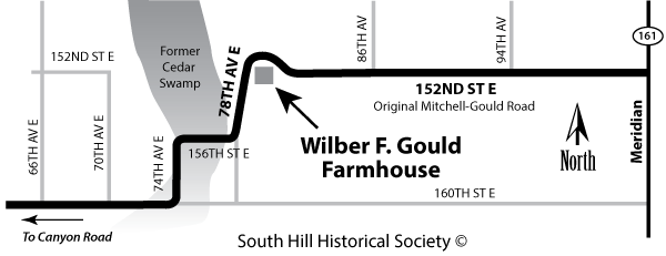
At the theoretical intersection of 152nd Street and 78th Avenue there seems to be no reason why the two roads should not come together at right angles. But as most drivers know, they do not. About one-quarter mile east 152nd Street flares to the north and then sort of wraps around what should have been the elbows of the two paths. Also, 78th Avenue is at an angle to the Section line.
It was in 1925 that 152nd Street (known as Mitchell-Gould Road) was built across the middle of Section 21 to what is now 86th Avenue. Then in 1931 the road was extended to what is now Canyon Road (See: The Herald, October 9, 2008, page B3). The new street, the Mitchell-Gould Extension, was built west across Section 20 and then south along what is now 78th Avenue. To build directly to Canyon Road (then known as McLarty Road) was impossible because of a steep hill leading into a deep depression, or more accurately, into a swamp. Some people refer to that area as Cedar Swamp while others call it Starvation Valley.
When laying out the Extension it was discovered that a farmhouse was located on the Section line just east of the intersection, the homestead of the Wilber F. Gould family. The Gould’s had acquired the 160-acre farm in 1889. While it had been modified several times the original building was still in place and the road path as envisioned would require constructing it directly through the house. Going around it solved the problem.
It should be pointed out that in 1931 the Wilber Gould family no longer lived in the original house. In 1912 a new home had built further east on the property. The old house was still being used, however, as a home for his son and wife.
The original house is no longer there. It remained on the property until about 1951, when the Blyton family, who by then owned the old Gould property, took it down. In fact, all the original structures in that area have been removed for a modern subdivision. All that’s left is the divergence place in an otherwise straight roadway.
Carl Vest, PhD, is a founding member and Research Director for the South Hill Historical Society.